@jovirkku, It is an XA2 dual sim with one sim card, location service is on and high precision positioning is selected. GPSinfo shows that the GPS is active. I was assuming that @crun could not get a fix. It seems to me that in this state the number of satellites just stays the same all the time. You can go outside and point the phone to the sky and maybe it’ll work after a shorter or longer time. At any rate, it is hardly satisfactory that you can’t get a fix inside a confined space like e.g. a car. If this issue isn’t resolved, I guess I have to try LineageOS or something.
@mortenbo Yes. I am not claiming that it would work fluently. But then, some people put it as if it did not work at all. We have never seen that in our tests. If the phone has correctly installed Sailfish and no special tampering afterwards then the fix should arrive after few minutes at the latest. That is of course too slow. But it is a different problem if something works slowly or not at all. It requires different actions. That’s why it is important to report precisely.
Different phones have different assistance (or none) and different HW and AOSP. That causes variation to the results.
1 Like
I did not imply that it didn’t work at all - just that the number of satellites does not seem to be updated when the GPS is unable to get a fix. Anyway, it seems that you are a developer and is working on it which is reassuring.
Transmitting devices inside the phone are the WLAN chip, the bluetooth chip and the communication with the mobile net. While talking or transferring datas the mobile net connection transmits much more than while only in standby.
This transmitting devices inside the phone are in a distance of only millimeters or centimeters from the built in GPS receiver of the phone. This may cause interferences and malfunction of the GPS receiver. Having another phone with you should have no effect if the distance is more than a few or 10 centimeters.
I was testing inside a light builded garden house in rural area.
@Seven.of.nine: Ok, thanks, I misunderstood. It sounded to me as if you would have a number of peripheral devices around you transmitting something. 
It would difficult to avoid the internal devices from transmitting and shouldn’t even be done, or else the assisted positioning cannot work.
I tried 10 minutes ago, while writing to you before, with internet connection on and mobile accesspoint on, to get a position fix, and nothing! 1 or 2 satellites visible and 0 sat’s sync’d and no display of position.
Then I changed to flight mode, GPS manually on, got position fix in a few seconds!
Now as I write this second post - try to get position fix - and nothing comes, as above.
All this on a X10 Dual SIM.
edit: I have here a WLAN range extender in abt. 1 meter distance to the phone, but this does not affect the GPS receiver of the X10. It was always on with running access point while testing GPS successfully. There are no other transmitting devices here. The WLAN range extender is connected with laptop and printer by cable.
Hi
GPS was working for me until 3.3. But after upgrading to 3.4, GpsInfo started showing 0/0 satellites indoors even if I left the app opened for 20 min(all the previous satellite list lost). Only after taking it outside and standing in the open ground after a few minutes satellites started to get listed and lock in happened.
If you use gpsinfo, it seems that you can’t rely on the number of satellites being shown. Gpsinfo just remembers the last number when the gps was working and doesn’t update it.
GPSInfo does continuously update the skymap view, and the info page is updated when I switch back to it. (I realise that I customised GPSInfo a while ago, so it might be a bit different to yours)
Since I have had sfos/xa2 (sept19), GPS has never been functional or usable.
- There has never been a fix under trees. Ever. Even standing under a single roadside tree stops it acquiring a fix. [My old winphone gets a fix under heavy forest cover, in <1minute, with no network, data, or sim, after being off for 2 weeks]
- It has never been usable for driving i.e. updating continuously in a timely fashion which is usable for navigation. It was always laggy (i.e. not getting continuous fixes making turn by turn useless) or just stops getting fixes after a while.
- using precision/location services helped somewhat (i.e you might get a fix in a minute or two), and when mozilla went offline the gps became completely useless. As an example the last fix I had using the map was 2 weeks ago, and it worked for less than 15 minutes. (driving). I turn the map on most days.
I understand that since mozilla shut the servers down all phones now have none. Where is this other service coming from?
There are pages of reports here, many of which are quite detailed. What there are not are questions (e.g. a checklist) we can answer, to get to the bottom of a major, long running, widely reported showstopper.[Oops- seems you did ask some questions, so I answer them below]
Nor any diagnostics. e.g. Why not make a custom version of GPSInfo to help debug this?
Perhaps you could say what your tests have shown? Then we can give more relevant feedback
- which phone is this?
XA2 Dual sim 4133 - does it have an active SIM card in it?
Yes - are the time and date correct on the phone
Yes - have you turned Settings > Location service on, and preferably activated High accuracy positioning?
Yes. Both with and without HAP. - have you checked in the pulley of GPSinfo that the service is activated?
Yes, and obviously it is updating the skyview so must be working.
7 Likes
Discovery: Sats must be full green to be in use
Inside I have 27 sats, but 0 in use as usual. So I tried it (with GPSInfo) outside under a clear sky today, and got 7/40.
GPSInfo satellite skyview shows the sats coloured by (presumably) signal strength or quality, from red through green.
I realise that satellites are only in “use” when they are fully green .If they are even one step off full green, they will not be in-use. From what I can see, until there are at least 6 fully green satellites , there will remain 0 in use. As some drop below full green the number will drop to 5,4,3 .
This would explain
- Never works under trees or inside
- works poorly driving
- Often doesn’t really work outside.
If it only is able to get a good enough signal from 7 of 40 sats under a clear sky, it is really very marginal. Note that other GPS will get fixes with 6 weak satellites. Seems that the threshold to use a satellite is all wrong
Please other people test my observation, and see if you have the same.
3 Likes
My story
around 8:45 I turned off and then on my Xperia 10 dual sim 3.4.0.24 (according to device info in Settings), indoors about 2 m from window
8:53 GPSInfo on, 27 red satellites, 0/27
8:57 1 orange, 25 red, 0/26
9:06 1 light orange, 1 orange, 0/26
9:08 1 yellow, 3 orange, 1 dark orange, 0/26
9:22 1 yellow, 3 orange, 0/26
9:30 outside, clear sky above, within half minute almost all satellites turn to green or yellow, 5/42
1 Like
These are GPS basics. You need 3 satellites for a bare hope to get a (not much reliable) fix. I note that modern receivers won’t take a fix for got with less than 5 satellites.
Anyway, GPSInfo lacks a very important piece of information: the strength of the signal received from each satellite. The satellites that you see are the positions where the receiver thinks they should be. The satellites shown in green are the one the receiver is using to get the fix. An extremely annoying feature of GPSInfo is that you cannot know which satellites are really in view, ie the receiver is getting a signal from, and the intensity of this signal. This would be extremely helpful for debug. Unfortunately, the standard NMEA protocol (IEC 61162) does not provide this information. Getting it requires the use of custom manufacturer protocols, which vary from device to device.
This might be a bit off topic but updating the last known location seems quite odd.
In the morning I turn the gps on and place the phone outside for a while to get a gps lock. I ride to my job with the gps on and it’s working fine. I turn gps off.
In the afternoon I turn the gps on at my work place. While waiting for the gps lock phone shows that I’m still at home where I was in the morning. I checked the map on Meerun and also checked the gps coordinates from GPSInfo.
So if there’s no gps lock then it seems that the phone thinks it’s in the location where the gps lock was last time acquired, not in the last time the location was updated. But this doesn’t seem to be how it works. Because when I get back home and turn gps off, the phone correctly shows my home location.
A few weeks ago I was some 150 km away and the phone hold on to that location for a week even though I was using gps every day. So if gps wasn’t on or there was no lock the phone showed I was 150 km from my current location. When gps lock was acquired then location was updated to my real location. At some point the “offline location” moved to my home location.
This behaviour could have consequences for example when making a emergency call. If the phone doesn’t have gps lock at the moment of the call It would be better to transmit the last actual known location not some point where you’ve been several days ago.
This could be of course just these two apps I was testing this on.
1 Like
I’ve been using my XA2 in device only mode and gps is some what usable. I can get a lock but sometimes it takes a long time. And you have to be outside and in an reasonably open location without buildings around.
Every now and then gps lock is lost during use and then regained again some minutes later.
So it works but is definitely not as good that it used to be.
1 Like
This is incorrect…
The colour indicates actual signal strength (source code). As soon as I go under cover (within 10s), the color changes → red (even when there is no fix) so it works in practice.
When a satellite is in use, it appears to get a white border, even when it is no longer green.
The numbers are satellite identifier. I see numbers as high as 327, ( GPS + GLONASS supported according to Sony) I note that some sats are red even when directly overhead.
2 Likes
Yesterday I tried again outside about 1 hour after previously getting a fix.
It got a 6/40 fix after 7minutes. This got up to 9/39 after 11mins. When I cam inside it dropped to 3/39, then lost fix.
Today I turned gpsinfo on inside. 0/25 red sats
0:30s go outside, sats start turning green within 3 secs.
2:18 7/44 lock. Also a bunch of extra (red) sats appear
3:30: 9/43
under tree - still has lock
back inside - still has lock 6/40 in middle of house (steel roof), 8/42 1m from windows. Not losing lock.
So left it sunning inside ~1m from window, and it stayed running.
Then I went out in the car, and it was getting 17/42 inside the car.
This is suggesting that it might have old stale data that is stopping it reliably acquiring sats when turned on, and since it doesn’t get fix, the situation persists,
Is there some way to force a full cold start on the GPS perhaps?
This might be a bit off topic but updating the last known location seems quite odd.
A few weeks ago I was some 150 km away and the phone hold on to that location for a week even though I was using gps every day. So if gps wasn’t on or there was no lock the phone showed I was 150 km from my current location. When gps lock was acquired then location was updated to my real location. At some point the “offline location” moved to my home location.
I think I’ve witnessed the same behaviour, but I’m on Xperia X so in that case this might well be different issue than the topic here. I’m not a big user of GPS, so it’s not as clear as what you are describing, but I seem to remember cases where the initial position reverted to somewhere I was at some time ago, whilst having been using GPS elsewhere since then. FWIW, I mostly use modRana.
And to make it clear, I don’t have issues getting a GPS fix (but as said, I’m not using XA/XA2).
Yes, red/green is in sight/not in sight, sorry, but it’s not a signal strength. This is what I mean by satellite signal strength:
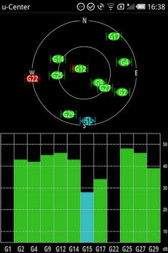
This screenshot is from u-Center from u-Blox. It uses a custom protocol to get it though.
Yes its is.
Apart from how it is obviously working, I quote from the original source code (of GPSInfo by Balta):
var hue = (sat.signalStrength < 40 ? sat.signalStrength : 40) * 3;
1 Like
Indeed I just found that NMEA sentence GSV, although not RSSI, provides SNR for each satellite, so a representation of reception quality can be done. Nevertheless, a bar graph would be far more readable than the hue value. I was not aware of this bit.